Difference between revisions of "Angel Island"
| (One intermediate revision by the same user not shown) | |||
| Line 1: | Line 1: | ||
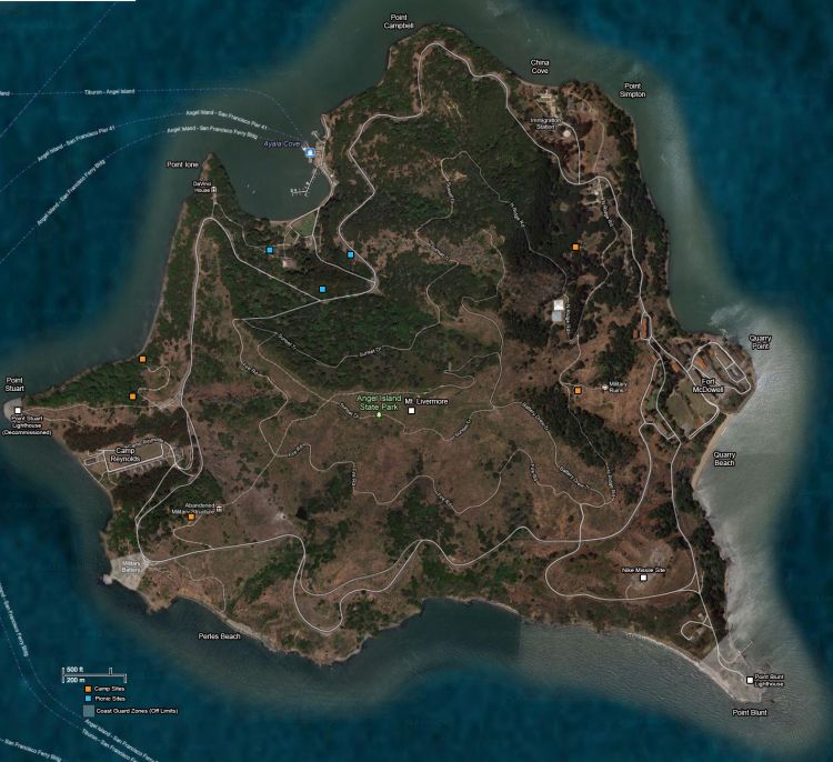
| − | [[Image:Angel-island-lg.jpg| | + | [[Image:Angel-island-lg.jpg|750px|right|Angel Island Map]] |
'''[[http://en.wikipedia.org/wiki/Angel_Island_%28California%29| Wikipedia Article]] | '''[[http://en.wikipedia.org/wiki/Angel_Island_%28California%29| Wikipedia Article]] | ||
| + | ==Natural History== | ||
| + | Ten thousand years ago, the island was connected to the mainland. Angel Island was created by the rise of the oceans at the end of the ice age. | ||
| + | ===Plant Life=== | ||
| + | In the 1800s, cattle grazing and wood harvesting eliminated the oak woodland and coastal brush habitat covering Angel Island. The U.S. Army and the Immigration Service planted many non-native trees such as eucalyptus and Monterey pine. Since the creation of the state park in 1963, oak, bay, madrone and other native trees and shrubs are reclaiming their habitats. Wildflowers cover the island in spring. | ||
| + | ===Animal Life=== | ||
| + | Deer and raccoons, both excellent swimmers, are the only large land mammals on the island. Harbor seals and California sea lions often sun on the rocks. Birds include scrub jays, hummingbirds, flickers, hawks and owls. Near the coves, visitors may find egrets, grebes, blue herons and brown pelicans. | ||
| + | ==Notable Sites== | ||
| + | ===Coast Guard Zones (Off-Limits)=== | ||
| + | * '''Point Stuart:''' X | ||
| + | * '''Point Knox:''' X | ||
| + | * '''Point Blunt:''' X | ||
| + | ===Historical & Military Sites=== | ||
| + | * '''U.S. Immigration Station:''' X | ||
| + | * '''Fort McDowell:''' X | ||
| + | * '''Nike Missile Site:''' X | ||
| + | * '''Weapons Batteries:''' X | ||
| + | * '''Camp Reynolds:''' X | ||
| + | ===Ayala Cove=== | ||
| + | X | ||
| + | ===Tourist Attractions=== | ||
| + | * '''Beaches:''' Quarry Beach, China Cove, Perles Beach | ||
| + | * '''Picnic Sites:''' X | ||
| + | * '''Camping Sites:''' X | ||
| + | * '''Trails:''' X | ||
| + | * '''Mount Livermore:''' X | ||
| + | ===Private Property=== | ||
| + | * '''Point Ione & the [[DaVinci House]]:''' X | ||
Latest revision as of 14:24, 20 July 2012
Contents
Natural History
Ten thousand years ago, the island was connected to the mainland. Angel Island was created by the rise of the oceans at the end of the ice age.
Plant Life
In the 1800s, cattle grazing and wood harvesting eliminated the oak woodland and coastal brush habitat covering Angel Island. The U.S. Army and the Immigration Service planted many non-native trees such as eucalyptus and Monterey pine. Since the creation of the state park in 1963, oak, bay, madrone and other native trees and shrubs are reclaiming their habitats. Wildflowers cover the island in spring.
Animal Life
Deer and raccoons, both excellent swimmers, are the only large land mammals on the island. Harbor seals and California sea lions often sun on the rocks. Birds include scrub jays, hummingbirds, flickers, hawks and owls. Near the coves, visitors may find egrets, grebes, blue herons and brown pelicans.
Notable Sites
Coast Guard Zones (Off-Limits)
- Point Stuart: X
- Point Knox: X
- Point Blunt: X
Historical & Military Sites
- U.S. Immigration Station: X
- Fort McDowell: X
- Nike Missile Site: X
- Weapons Batteries: X
- Camp Reynolds: X
Ayala Cove
X
Tourist Attractions
- Beaches: Quarry Beach, China Cove, Perles Beach
- Picnic Sites: X
- Camping Sites: X
- Trails: X
- Mount Livermore: X
Private Property
- Point Ione & the DaVinci House: X
