Template:Astoria Sidebar
From OakthorneWiki
Jump to navigationJump to searchAstoria, Oregon
|
| Country: United States State: Oregon County: Clatsop Founded: 1811 Incorporated: 1876 Mayor: xxx ZIP Code: 97103 Area Code(s): 503 and 971 Website: City of Astoria |
Area
|
| Total: 10.11 sq mi (26.18 km2) Land: 6.16 sq mi (15.95 km2) Water: 3.95 sq mi (10.23 km2) Elevation: 23ft (7m) |
Population (2010)
|
| Total: 9,600 Density: 1,538.5/sq mi (594.0/km2) Ethnicities: White (90%), Hispanic (5%), Black (1%), Asian (2%), Pacific Islander (1%), Other (15) Ancestries: German (15%), Irish (12%), English (10%), Finnish (6%), Norwegian (6%), Scottish (6%) Income: $33,000 per annum (household), $42,000 per annum (family), 16% below poverty line |
City Layout
|
| Total: 10.11 sq mi (26.18 km2) Land: 6.16 sq mi (15.95 km2) Water: 3.95 sq mi (10.23 km2) Elevation: 23ft (7m) |
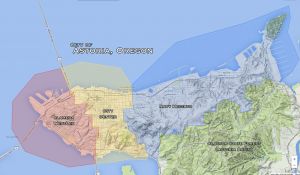
| Districts: City Center • Alameda WestLex • Navy Heights Points of Interest: University of Astoria • Astoria Column |

