Astoria
Astoria, Oregon
|
| Country: United States State: Oregon County: Clatsop Founded: 1811 Incorporated: 1876 Mayor: Aubrey Astor ZIP Code: 97103 Area Code(s): 503 and 971 Website: City of Astoria |
Area
|
| Total: 10.11 sq mi (26.18 km2) Land: 6.16 sq mi (15.95 km2) Water: 3.95 sq mi (10.23 km2) Elevation: 23ft (7m) |
Population (2010)
|
| Total: 9,600 Density: 1,538.5/sq mi (594.0/km2) Ethnicities: White (90%), Hispanic (5%), Black (1%), Asian (2%), Pacific Islander (1%), Other (15) Ancestries: German (15%), Irish (12%), English (10%), Finnish (6%), Norwegian (6%), Scottish (6%) Income: $33,000 per annum (household), $42,000 per annum (family), 16% below poverty line |
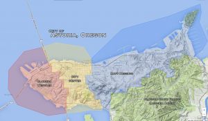
City Layout
|
| Total: 10.11 sq mi (26.18 km2) Land: 6.16 sq mi (15.95 km2) Water: 3.95 sq mi (10.23 km2) Elevation: 23ft (7m) |
Neighborhoods
|
| City Center: (Low-Mid) Astoria Column • Bank of Astoria • Blue Ocean Thai • Crossroads • Dollhouse Hair Salon (and Warner's Loft) • Drina Daisy • Elaine's House • Kaffe • University of Astoria • Wet Dog Cafe Alameda WestLex: (Mid) Old Ojala Cannery Warehouse • Youngs River Lofts |
A small town in the northwest corner of Oregon along the coast, Astoria is an old fishing and fur-trading settlement on land that was originally occupied by the Clatsop tribe. Named for its first millionaire, John Jacob Astor, Astoria grew up around the fort founded by Astor's fur trading company in 1810. It also boasts a deep water port that sees very little shipping trade, though it still maintains a decent fishing industry. It is also a port of call for a number of cruise lines sailing up and down the West Coast. This port attracted a number of immigrants in the late Nineteenth Century, mainly Scandinavians (particularly Finns, who worked the fisheries) and Chinese (who found work in the canneries).
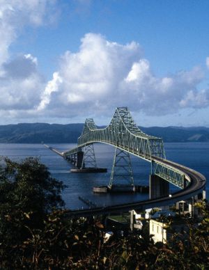
Many people refer to Astoria as "Little San Francisco," as the small town shares some similarities with the Golden Gate City: both are coastal, dominated by massive bridges, with touristy waterfront areas and boardwalks with impressive populations of sea lions, and are both well-known for their trolleys that run along that boardwalk. Both of them also feature hills overlooking the city, on which are built a variety of interesting and well-preserved Victorian-style homes.
Contents
Facts & Figures
Astoria is a city of 10,000 people on the Columbia River, just a few miles from the Pacific Ocean located in Clatsop County. It is surrounded by the beauty of the forest, mountains, 3 rivers and the sea. Because of its steep hills and beautiful Victorian homes, Astoria has been Called the “Little San Francisco of the Pacific Northwest.” Just across Youngs Bay is Warrenton, a city of 4,500, that encompasses Fort Stevens State Park and its broad, clean ocean beaches.
Astoria and Warrenton have a marine climate, which means the summers are cool, with highs around 70, and the winters are mild, with few nights of freezing temperatures. The area gets about 75 inches of rain per year, which accounts for its vivid greenness and crystal clear air. Winter storms can be dramatic with winds reaching 70 to 100 miles per hour on the ocean bluffs. The area has a strong Scandinavian heritage.
History
In May, 1792, American Captain Robert Gray sailed his 230-ton Columbia Rediviva between Point Adams in what is now Oregon and Cape Disappointment in what is now Washington to first enter the Columbia River. Ten years later, President Thomas Jefferson asked his personal secretary, Army Captain Meriwether Lewis, to lead an expedition to the Pacific to find “...whether the Columbia, Oregen, Colorado, or any other river may offer the most direct and practicable water communication across this continent for the purposes of commerce”.
The Lewis and Clark Expedition left Pittsburgh August 31, 1803. The Corps of Discovery entered the Lower Columbia River in November of 1805 and stayed through March 1806. They “wintered over” at Fort Clatsop, where it rained all but 12 days, hunting, making moccasins and other clothing, trading with the Clatsop, Tillamook, and Chinook Indians, and working on their journals.
In 1811, five years after the departure of Lewis & Clark, John Jacob Astor, a New York financier, sent fur traders aboard the ship Tonquin to establish a trading post. They built Fort Astoria on a site now preserved as a monument in the downtown area.
Well over 200 major shipwrecks have occurred near the mouth of the Columbia River – known for a century as “The Graveyard of the Pacific.” One, the Peter Iredale of 1906, is still visible on the beach at Fort Stevens State Park. Native Americans lived in the area for an estimated 10,000 years before Captain Gray’s arrival.
Links of Interest
- Astoria page at Wikipedia.
- Map of Astoria
- Chamber of Commerce: | Astoria & Warrenton Chamber of Commerce; | Visitor's Guide; | Visitor's Map to Astoria
- Youtube Videos: | Astoria Video Tour; | Astoria-Warrenton Audio Tour Advert
Astoria Districts
- City Center: The oldest part of town, including the historic Old Town Astoria along the northern shore of the Columbia.
- Alameda WestLex: An industrial and mercantile dock area, as well as location of hill-side homes.
- Navy Heights: The eastern stretch of territory along the Columbia shoreline and north of the Astoria Basin of the Clatsop State Forest, made up of a handful of tiny communities, notably Navy Heights and Tongue Point Village.
- Cathlamet: The small community in the eastern portion of the Astoria Basin Peninsula, which abuts Cathlamet Bay.
- Greenwood: Very rural area southwest of the Astoria Basin Clatsop State Forest, mostly known for its large cemetery.
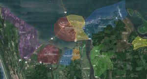
Nearby Areas
Other Small Towns
All of the following have populations of less than 500, and many of only a few hundred
- Jeffers Garden, a small town south of Astoria, east across the Lewis & Clark River from Warrenton
- Miles Crossing, a small town south of Astoria, east of Jeffers Garden
- Fern Hill, a small town southeast of Astoria along Cathlamet Bay


